Shasta National Forest's Biotic Communities
Western North America Alpine Tundra
Conditions
Western North America Alpine Tundra (WNA Alpine Tundra) ecosystems are found on mountain ranges along the west coast of North America, including the mid-elevations on Mount Shasta (Billings & Meidinger 2015). This ecosystem is characterized by short growing seasons and long winters with high snowpack. Soils in this ecosystem tend to be shallow, rocky, low in organics, and well drained (Billings & Meidinger 2015).
Plant Communities
Plants commonly found in the WNA Alpine Tundra ecosystem on Mount Shasta include wildflowers in the genus Eriogonum, like Sulphur Buckwheat (Eriogonum umbellatum), and some trees at lower elevations such as Lodgepole Pine (Pinus contorta) (Billings & Meidinger 2015; Anderson 2003; United States Department of Agriculture (USDA) & United States Forest Service (USFS) 2016; USDA & USFS 2014).
 |
| Sulphur Buckwheat. Source. |
 |
| Sulphur Buckwheat's distribution in the Shasta National Forest. Source. |
 | ||
Lodgepole Pine. Source.
|

Sulphur Buckwheat is able to survive the cold conditions of the WNA Alpine Tundra by growing close to the ground, protecting the plant from wind and allowing the plant to absorb warmth from the surface (Dyer & O'Beck 2005; Davidson 2018). It’s distribution is limited by its low moisture needs, as it cannot tolerate more saturated soils or higher water tables found more commonly at lower elevations in areas around Lake Shasta (Dyer & O'Beck 2005).
Lodgepole Pines are adapted to growing in nutrient poor soils, allowing them to grow in the rocky soils found in this ecosystem (Anderson, M.D. 2003; Calscape 2021; USDA & USFS 2014). The distribution of Lodgepole Pine is also limited by its water needs, as it prefers to grow in well drained soils with water supplied by snow not found at lower elevations (Anderson, M.D. 2003; Calscape 2021; USDA & USFS 2014).
Rocky Mountain Forest & Woodland
Conditions
Rocky Mountain Forest and Woodland (RMFW) ecosystems are commonly found below alpine ecosystems in continental areas of western North America and make up a large portion of the Shasta National Forest (Peet & Meidiner 2015). This ecosystem is characterized by variable precipitation ranging from 25cm-240cm annually with winter snow and seasonal drought periods (Peet & Meidiner 2015).
Plant Communities
Trees commonly found in RMFW ecosystems and the Shasta National Forest include Ponderosa Pine (Pinus ponderosa) and Douglas Fir (Pseudotsuga menziesii) (Peet & Meidiner 2015; USDA & USFS 2014).
 |
| Ponderosa Pine. Source. |
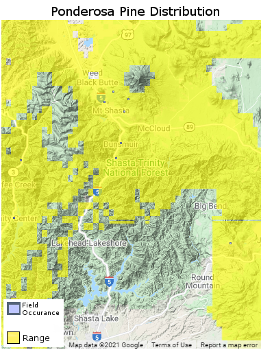 |
| Ponderosa Pine's distribution in the Shasta National Forest. Source. |
 |
| Douglas Fir. Source. |
 |
| Douglas Fir's distribution in the Shasta National Forest. Source. |
Ponderosa Pine is a rapid grower and has high heat and drought tolerance once established, allowing it to survive the variable precipitation and drought periods in this ecosystem (Wennerberg 2004; USDA & USFS 2014). Douglas Firs are highly adaptable to a range of temperatures and levels of precipitation (Anderson, K.M. 2008; Watts et al 2015; USDA & USFS 2014); They are able to grow needles of different thicknesses depending on temperature and moisture conditions to control transpiration rates (Watts et al 2015). This unique adaptation makes Douglas Fir well suited to the highly variable conditions found in RMFW ecosystems (Anderson, K.M. 2008; Watts et al 2015; Peet & Meidiner 2015). The distribution of both Ponderosa Pine and Douglas Fir are largely limited by their low water needs, as they both can be over watered in poorly draining soils or in areas with high water tables, such as near Lake Shasta (Wennerberg 2004; Anderson, K.M. 2008).
Temperate Freshwater Lake
Conditions
Temperate Freshwater Lake ecosystems have a salinity under 0.5ppt, with dissolved minerals and nutrients varying depending on local hydrology, geology, and the surrounding surface environment (Hierarchy Revisions Working Group et al 2016). Oxygen and nutrients cycle throughout the water column, but greater depths can still have lower oxygen levels than closer to the surface (Hierarchy Revisions Working Group et al 2016). Vegetation in this ecosystem occurs either as floating plants or in rooted plants in the shallower water along the banks (Hierarchy Revisions Working Group et al 2016).
Fish & Plant Communities
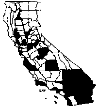
Spotted Bass (Micropterus punctulatus), while non-native, are commonly found in Lake Shasta, as they are stocked for sports fishing (Hierarchy Revisions Working Group et al 2016; USDA & USFS 2015). Spotted Bass are adaptable and can thrive in both flowing water and lakes or reservoirs. They also eat a wide variety of prey including crustaceans, frogs, salamanders, worms, grubs, and smaller species of fish (Fuller & Neilson 2021; Froese & Ortanez 2021). This generalist approach has allowed Spotted Bass to establish themselves in Lake Shasta and many other bodies of water where they are non-native (Fuller & Neilson 2021; Froese & Ortanez 2021). The distribution of Spotted Bass is limited by the connectedness of waterways in which they could travel (Fuller & Neilson 2021; Froese & Ortanez 2021).
 |
| Spotted Bass. Source. |
 |
| Spotted Bass' range across the United States. Source. |
An invasive aquatic plant once found submerged along the banks of Lake Shasta is Hydrilla (Hydrilla verticillata) (CAL IPC 2021). Hydrilla is perennial, meaning it can go dormant to survive during the colder periods in the region (CAL IPC 2021). It also spreads vegetatively, meaning any piece separated from the parent plant can grow into a new plant, making it very successful at spreading (CAL IPC 2021). Hydrilla’s distribution is limited both by the connectedness of waterways where it is present and human efforts to control its spread in California (CAL IPC 2021).
 |
| Hydrilla. Source. |
 |
| Hydrilla's distribution by county in California. Source. |
Shasta National Forest's Disturbance Regime
The dominant natural disturbance process in all three areas of the Shasta National Forest is fire, varying in intensity by location and season (United States Geological Survey (USGS) 2021; Frost & Sweeney 2000). The steep slopes and large expanses of uninterrupted vegetation allow for wildfires to spread over large areas (Frost & Sweeney 2000). Fires are typically ignited by lightning or human activity, with September having the highest number of ignitions (Frost & Sweeney 2000). The frequency of fire is highly variable, with fires occurring every 3 to 71 years (Frost & Sweeney 2000). The severity of wildfires in the Shasta National Forest tend to be low to moderate severity, with high severity patches only accounting for 15-20% of total area burned (Frost & Sweeney 2000).
 |
| Aftermath of the 2018 Carr Fire, which burned portions of the Shasta National Forest and Redding, CA. Source. |
 |
| More aftermath of the 2018 Carr Fire, with this devastation having occurred just to the west of Lake Shasta. Source. |
Lodgepole Pines have serotinous cones, an adaptation to more severe stand-replacing fires, and only open and release seeds after a fire event (Anderson, M.D. 2003). Ponderosa Pines, on the other hand, are adapted to survive low to moderate severity surface fires with their thick bark (Fryer 2018). Crown fires will kill seeds stored in Ponderosa cones and will also kill Ponderosa Pines of any age / size (Fryer 2018). Douglas Firs are similar to Ponderosa Pines in their ability to survive low to moderate severity surface fires through thicker bark (Steinberg 2002). However, Douglas Firs takes longer, around 40 years in moist sites, to develop a thicker, fire-resistant bark, making them less resistant to fire than Ponderosa Pine (Steinberg 2002). Douglas Firs and their seeds are also killed by crown fires (Steinberg 2002).
Literature Cited
Anderson, K. M. (2008). Plant Guide: Douglas Fir. United States Department of Agriculture. https://plants.usda.gov/plantguide/pdf/cs_psme.pdf
Anderson, M. D. (2003). Fire Effects Information System: Pinus contorta var. latifolia. United States Department of Agriculture, United States Forest Service. https://www.fs.fed.us/database/feis/plants/tree/pinconl/all.html#BOTANICAL%20AND%20ECOLOGICAL%20CHARACTERISTICS
Billings, W. D., & Meidinger, D. (2015). Division: Western North America Alpine Tundra. https://explorer.natureserve.org/Taxon/ELEMENT_GLOBAL.2.860370/Phyllodoce_glanduliflora_-_Dryas_spp_-_Festuca_altaica_Alpine_Tundra_Division
Calscape. (2021). Lodgepole Pine: Pinus contorta. California Native Plant Society. https://calscape.org/loc-California/Pinus%20contorta%20(Beach%20Pine)?newsearch=1
CAL IPC. (2021). IPCW Plant Report: Hydrilla verticillata. https://www.cal-ipc.org/resources/library/publications/ipcw/report57/
Davidson, E. (2018). Plant Adaptations in the Tundra. https://sciencing.com/plant-adaptations-tundra-8042887.html
Dyer, D., & O'Beck, R. (2005). Plate Guide: Sulfur Flower Buckwheat. United States Department of Agriculture. https://plants.usda.gov/plantguide/pdf/pg_erum.pdf
Froese, R., & Ortanez, A. K. (2021). Micropterus punctulatus (Rafinesque 1819): Spotted bass https://www.fishbase.se/summary/Micropterus-punctulatus.html
Frost, E. J., & Sweeney, R. (2000). Fire Regimes, Fire History and Forest
Conditions in the Klamath-Siskiyou Region:
An Overview and Synthesis of Knowledge. World Wildlife Fund. https://sipnuuk.karuk.us/system/files/atoms/file/AFRIFoodSecurity_UCB_ArielleHalpern_002_001.pdf
Fryer, J. L. (2018). Pinus ponderosa var. benthamiana, P. p. var. ponderosa: Ponderosa pine. United States Department of Agriculture https://www.fs.fed.us/database/feis/plants/tree/pinponp/all.pdf
Fuller, P., Cannister, M., & Neilson, M. (2021). Micropterus punctulatus. United States Geological Survey. https://nas.er.usgs.gov/queries/factsheet.aspx?SpeciesID=397
Hierarchy Revisions Working Group, Faber-Langendoen, D., National Wetlands Working Group, & Lea, C. (2016). Temperate to Polar Freshwater Aquatic Vegetation. https://explorer.natureserve.org/Taxon/ELEMENT_GLOBAL.2.877233/Temperate_to_Polar_Freshwater_Aquatic_Vegetation_Formation
Peet, R. K., & Meidiner, D. (2015). Division: Rocky Mountain Forest & Woodland. https://explorer.natureserve.org/Taxon/ELEMENT_GLOBAL.2.872779/Pseudotsuga_menziesii_-_Tsuga_heterophylla_-_Abies_lasiocarpa_Forest_Woodland_Division
Steinberg, P. D. (2002). Pseudotsuga menziesii var. glauca. United States Department of Agriculture. https://www.fs.fed.us/database/feis/plants/tree/psemeng/all.html#FIRE%20ECOLOGY
United States Department of Agriculture, & United States Forest Service. (2014). Trees of the Shasta-Trinity. https://www.fs.usda.gov/Internet/FSE_DOCUMENTS/fsm9_008614.pdf
---. (2015). Fishing at Shasta-Trinity. https://www.fs.usda.gov/Internet/FSE_DOCUMENTS/fsm9_008261.pdf
---. (2016). Wildflowers of the Shasta-Trinity. https://www.fs.usda.gov/Internet/FSE_DOCUMENTS/fsm9_008263.pdf
United States Geological Survey. (2021). LANDFIRE Data Distribution Site. ESRI. https://landfire.gov/viewer/viewer.html
Watts, A., Bansal, S., Harrington, C., & St. Clair, B. (2015). Predicting Douglas-Fir's Response to a Warming Climate. Science Findings(179).
Wennerberg, S. (2004). Plant Guide: Ponderosa Pine. United States Department of Agriculture. https://plants.usda.gov/plantguide/pdf/pg_pipo.pdf
Comments
Post a Comment