The White River National wildlife refuge consists of multiple different species of plants and animals that are associated with that of bottomland communities. The four main vegetation species that are in this area are Overcup oak- Bitter Pecan (30%), Oak-Sugarberry (30%), Oak-Gum (25%), and Cypress (4%). These hard woods provide great habitat and food sources for amines such as white tailed deer, ivory-billed woodpeckers, gray/ fox squirrels, waterfowl, and many other species. Of the three locations I have chosen consists of wet bottomland forest, upland areas, and moist bottomland forest.
Wet Bottomland Forest
These communities consists of multiple different species but the two we are going to focus on are Bald Cypress trees and the Black Sandshell (Ligumia recta). Bald Cypress inhabit areas that are commonly flooded through the year as they have special adaptations that allow them to survive in heavily wet areas. These unique trees are most often found in oxbow lakes of the river or back water locations that remain flooded regularly but are not part of the main river channel (Connor, et al., 2012). This species is successful in this area due to adequate amounts of water resources and soil nutrients from river sediments.
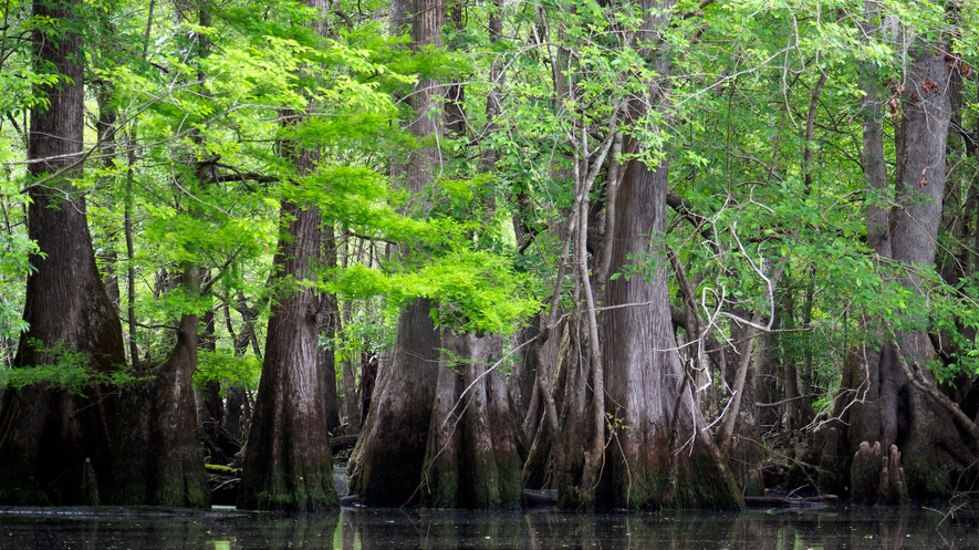 (Mongabay, 2019)
The Black Sandshell is a species that is found in this community location as well due to a few specific aspects. These organisms must have water to survive and they travel only small distances from where they first settles as juveniles (Connor, et al., 2012). This species is successful in these locations due to slower moving current and plenty of organic matter for filter feeding (MNH, 2021).
(Ligumia Recta, 2018)
Upland
Upland areas in the reserve are limited but grass and broad leaf plants provide habitat for a few important species such as the Eastern cottontail rabbit. One of the most common grasses being Johnson grass provide great cover for the rabbits and other small mammals or reptiles such as turtles. Johnson grass survive well in this area due to extensive sun light availability and moderate rainfall (Mullinex, 2021). These plants provide not only cover for different animal species, but they also provide a food source for different seed eating birds such as mourning doves.
(Mullinex, 2021).
The Eastern Cotton tail rabbit is successful in this environment due to cover from the different types of grass and the readily available food source.
 (PBS, N. H., 2021)
Moist bottomland Forest
The next community that we discus is the most reverent in the White River Refuge. These areas are covered with many different plants and provide shelter for many different animal species. The plant species that is most prevalent in this area is the Overlap Oak accounting for approximately 30% of the Refugees forest. This tree species survives well in its environment due to moderate water little flooding and optimal sun availability. The soil in this area is also nutritious rich allowing for all the minerals the species need to survive (Connor, et al., 2012).

The other species is also plentiful intros community is white-tailed deer. This species has cover, food, and small amounts of predators (other than hunters) in this area that make it great habitat. Although this species is able to travel moderate distances its dispersal is not vast in certain times of the year. When the river floods deer are not able to swim across the river due to faster current but they can wonder into both wet bottoms and the upland areas during different parts of the year.
(Dacus, 2018)

From looking at this you can see at what locations these species live in. For the wet bottomland environment species they inhabit waterbody areas which are blue on this map. The upland species inhabit the upland areas that are dark red. The moist forest environment is all of the green that is at least 1 mile from the water bodies. The deer and rabbits are able to travel into the different environments but predominantly inhabit their specific environment. The Black Sandshell inhabits water bodies or the banks of the water bodies if water levels fall at a faster rate than their means of travel. All three plant species inhabit their specific regions due to the adequate resources needed for survival.
(Connor, et al., 2012).
Disturbances
Wet bottomland forest
The most common disturbance in this location is of course flooding. The flooding can push the Black Sandshell up onto shore and when the river falls the mussels are not able to migrate back into the water causing them to die. With increase in climate change the rain fall patterns could continue to change dramatically causing either of the two extremes of drought or flooding (Connor, et al., 2012). The cypress trees have adapted to withstand amounts of water so that they are not as much at risk but if drought occurs the trees could potentially not have the nutrients needed to survive.
Upland
The upland area have a couple different disturbances that could take place to affect both of the species in this location. One of the disturbances would be a change in fire regimes if the AGFC didn't perform prescribed burns when appropriate the fire regime could change effecting not only the upland areas but also the Moist bottomlands (Connor, et al., 2012). The other disturbance that could affect this location would be the change in climate effecting the growth patterns of plants. A change in the growth patterns could affect pollinator patterns and cause a reduction in the cover and food resources for the easter cottontail.
Moist Bottomland
One disturbance of this area is the silvicultural harvest of the timber. What this does is allows light to penetrate though the forest canopy, creating a more successful understory which is used by many birds and deer as food sources, cover, and bedding/ nesting areas (Connor, et al., 2012). With the elimination of this disturbance deer populations would most likely be affected due to a decrease of cover and beading areas throughout the woods.
Sources
Connor, Matt, et al. “Comprehensive Conservation Planning - Dale Bumpers White River - U.S. Fish and Wildlife Service.” U.S. Fish & Wildlife Service, June 2012, www.fws.gov/refuge/White_River/what_we_do/planning.html.
Ligumia Recta, Georgia Department of Natural Resources , 2018, georgiabiodiversity.org/natels/profile?es_id=17868.
M. Dacus, C. (2018, April 13). Deer, White-Tailed. Mississippi Encyclopedia. https://mississippiencyclopedia.org/entries/white-tailed-deer/.
Mongabay. (2019). At 2,624 years, a bald cypress is oldest known living tree in eastern North America. Newsela. https://newsela.com/read/benchmark-12-bald-cypress/id/52552/.
Mullinex, Kim, et al. “Johnsongrass: Frequently Asked Questions.” Alabama Cooperative Extension System, 8 Mar. 2021, www.aces.edu/blog/topics/farming/johnsongrass-frequently-asked-questions/.
PBS, N. H. (2021). Eastern Cottontail - Sylvilagus floridanus - NatureWorks. New Hampshire PBS. https://nhpbs.org/natureworks/easterncottontail.htm.
Program, Montana Natural Heritage. “Montana Field Guide Black Sandshell - Ligumia Recta.” Black Sandshell, 13 Apr. 2021, fieldguide.mt.gov/speciesDetail.aspx?elcode=IMBIV26020.
Texas A&M Forest Service - Trees of Texas. Texas A&M Forest Service - Trees of Texas - List of Trees. (2021). http://texastreeid.tamu.edu/content/TreeDetails/?id=95.
Comments
Post a Comment